

URL: davidrumsey.com
Creator: David Rumsey, President, Cartography Associates, San Francisco, California
The Past as a Foreign Country: Exploring Historical Maps on the Internet
[quote]It appears that the operational domain of the mapping discourse extends far beyond the knowledge of space and enters our memory as well. In fact, it is through this mediation of historical maps that the domains of space and memory, with knowledge and sentiments, are transgressed. Thongchai Winichakul, Siam Mapped 1[/quote] Historic maps are much more than sources of archaic place names, locations of ancient settlement, or clues in the search for elusive lacunae in the historical record. Historic maps can be emblems of shared heritage and national narratives. They may be objects of beauty, creativity, imagination, and skill. They may also be handmaidens in nation-building and projects of imperial destiny, serving quests for territory, knowledge, and power. Historic maps are the two dimensional visions of a reality filtered through the imperfections of human understandingAccess to historic maps for education and research has been greatly enlarged by the world wide web. Like other kinds of important research resources – manuscripts, inscriptions, visual arts – historic maps can be studied in a digital environment in ways once impossible. Fragile texts can be photographed once and shared with thousands. Digital objects can be studied at leisure, magnified until the image finally dissolves in pixillation, combined for close study with digital objects drawn from collections continents apart. If the digital simulation represents a compromise with the texture, or aura, or tactile presence of its original, it nonetheless can offer rewards far more widely shared.
One of the finest websites for digital historic maps is davidrumsey.com. The website is a resource for teaching and research, and a model for possible future work in the area of Southeast Asian maps. It is not only of great potential use to those seeking historic map materials, but for work with maps as suggestive of cultural ideas, conceptions of space, and the political, economic, and social concerns of their era. In an era when metaphors of “mapping” are widely used in other disciplines, interest in maps and spatial information and its modes of representation and mediation seem also to be growing.
There are now many sites for maps on the web, most centered upon particular collections, some primarily portals to other resources. Highlights of this site include:
- the quality of the images in the on-line collection,
- the inclusion of Geographic Information Systems features, which can greatly expand possibilities for spatial analysis and data integration from multiple sources
- the moves toward expanded utility through interoperability with other on-line resources both in terms of search capability and display or results together with other related resources (such as art images).
This dataset review will comment on the scope and quality of the site both in terms of technology and content. The site was intended for educators, researchers, and those with historical or map interests generally. Users are reported to include K-12 teaching resource groups, university map libraries, history departments, to name a few. 2 Though Southeast Asianists are not by any means a primary intended audience, the site is useful particularly as a general existing map library resource, and as a model for what would also be possible in the Southeast Asia context.
Stability is one of the major concerns plaguing web-based research. While library books can be counted upon to remain on library shelves for years, decades, even centuries, websites appear, evolve, and disappear. Even sites with excellent content vanish. Backing by an established educational or governmental institution does not guarantee internet longevity, as instututional priorities and budgetary considerations change. Davidrumsey.com represents essentially the work of an individual specialist with vision, commitment, and resources. For a site based on an individual’s collection and personal resources davidrumsey.com promises stability and growth greater than many institutional sites. Davidrumsey.com first went online in March, 2000, has grown five-fold since its launch, and is poised to expand into greatly enhanced capacity as an online digital library hosting major image collections as well as maps.
The original maps are part of Rumsey’s collection, and the digital images created in his studio in San Francisco. As the maps are historic rather than contemporary, they are out of copyright. As owner of the artifacts as well as creator of the digital versions, David Rumsey holds copyright to all map material on the site, and chooses to waive restriction for educational use of the online collection. The online map archive now numbers some 10,000 maps. As the original historic map collection numbers some 150,000 items, this still represents under 10 percent of the available collection. The total current online count for Asia is about 500 maps, or less than 5 percent of the online collection. The focus of the collection is the Americas, though there are maps of all regions of the earth. Maps, atlases, globes, charts, and other representations of the earth’s surface are included. Special projects have brought additional map collections within online archive, such as digitizing the Japanese map collection at the University of California, Berkeley. This is one of the largest collections of Japanese maps in the world. Thus far 209 images from the maps and books have been included. The site continues to grow at a rapid pace.
The online documentation was developed for the original map library. Users can view the map metadata online, as well as retrieve map documentation from the original collection. The site is not managed or peer reviewed by an academic institution. However, Rumsey, through his association with Luna Imaging, Inc. and other collaborations, has been working with a number of high-profile museums and universities. The site is frequently updated, not in terms of eliminating obsolete data but adding to the online collection. Because the site focuses on historic maps, it is not time-sensitive in the way that sites dealing with current issues would be.
The greatest asset of this site is the quality of the images in the database. The images have been digitized at very high resolution. With on-screen magnification, even very fine detail can be seen and place-names read. This greatest of assets is also a liability in this respect: for those with inadequate internet connections, downloading these images can take time. This is a site with great rewards for the high bandwidth user. This is a concern for users in Southeast Asia, where high speed access is at best uneven. For those who do have good connections and access to good printers, images can be printed out of very high quality, approaching the look of map facsimiles.
The site employs Luna’s Insight® software for the map image database. This software has been widely marketed to museums with digital collections in the United States. The software has an elegant interface and ease of navigation. Several search options are open to users, including spatial and keyword searches. But its primary advantage is delivery of high quality images with flexibility of search and display. The resolution is such that images can be magnified to see even the smallest details.
The disadvantage is that this is proprietary software. The major concern with proprietary software, aside from cost, is that the company may reach a point where their products are no longer supported, or the company may disappear altogether. While the software is now used by a number of major institutions, suggesting confidence in its longevity, there are few guarantees on the internet. A further issue is the interoperability with other sites that employ Insight software. A consortium of museums and other cultural institutions using this software (including the site here under consideration) has formed searching across collections. This search capability is not at present available to the public, though plans are underway to develop a site that makes this available.
Users have two options for accessing maps in the website map collection: view images online with the internet browser (viewer), or download and install a feature-rich Java client. The customized ArcIMS (Internet Mapping System, a product of the ESRI software firm) site, developed with Berkeley-based Telemorphic Inc., allowed “quad view”: up to four images can be selected for view simultaneously, to compare layers in time. A drawback of the site, noted above, is slow download time due to the large file size of high resolution images. The Insight Browser and the Java Client can take up to one minute to load with a 28k modem, for example, though subsequent downloads tend to be shorter as some data is then cached locally.
The site is unusually clear about its technical requirements. These are listed on a menu on the home page of the site, with each of four available search options: the internet browser and java client described above, as well as a GIS (Geographic Information Systems) browser, for the small but growing GIS component of the collection, and the “Collections Ticker.” The Collections Ticker is a Flash-based thumbnail viewer that allows users to “scroll” through thumbnails and short descriptions of the entire collection of maps, charts, globes and other items (similar to a news or stock ticker). Also on the front page is “Help” access for users, and warnings of a few common problems likely to be encountered.
The site has examples of other technologies for spatial visualization. There are currently five maps in 3D that must be viewed in the 3D browser (http:www.davidrumsey.com/GIS/3d.htm). There are 123 georeferenced maps available now, mostly maps of the US andJapan, with numbers expected to grow The GIS browser (http:www.davidrumsey.com/GIS/index.htm) allows users to combine historic maps with layers such as satellite imagery and aerial photography. This is an area of considerable potential, especially for Southeast Asia, where satellite and aerial images are playing an increasingly important role in historical study.
A less exacting (and less time-consuming) but much more broad-based geo-referencing is being made available by ECAI (Electronic Cultural Atlas Initiative), with current count at 8,000 maps, or about 2/3 of the online collection. The balance of the online collection is scheduled to be completed by May, according to Dr. Ian Johnson, an archaeologist at the University of Sydney who is directing the project.
Metadata, or the descriptive terms for the “digital objects” (in this case maps) are registered in the ECAI Metadata Clearinghouse at theUniversity of Sydney (http://www.timemap.net/clearinghouse/html/index.html). These georeferenced maps can be retrieved from davidrumsey.com by spatial or keyword search at the Metadata Clearinghouse site, downloaded, and included in user-authored “map-spaces” along with other datasets downloaded from the internet or cached locally. Layers of overlaid maps from different eras help visualize changes over time for a specified area.
For those who wish to see examples of projects in which maps have been geo-registered, several are now available at the site, all from the U.S. or Japan at present (San Francisco, Los Angeles, Yosemite, Tokyo, Kyoto, Osaka). Projects will soon be online for New Yorkand Chicago as well. There is also one regional project, which follows the early nineteenth century journey of Lewis and Clark across western North America. Regional projects pose significantly greater problems than urban ones, as the latter encompass limited land area and can work at far larger scales. It is hoped that future studies can be done for Southeast Asia. An even more positive development would be a Southeast Asian scholar or organization that undertakes to produce similar projects with this work as a model.
Rumsey has made “fly-through” animations of some of his maps, using ArcScene to overlay his maps on a Digital Elevation Model (DEM), which provides the earth’s topography. The results may speak the language of young people already well accustomed to digital gaming environments. For others less familiar with the technology, the thrill of movement through digital space, guided by the cursor, may be even more impressive. This approach captures interest and, couched in guided learning environments, may be productive in encouraging new ways of seeing and experiencing historic maps, contemporary spaces, and spatial information. Concern has been expressed in relation to this site, as well as virtual reality and enhanced digital environments generally: that the technology overpowers the content, and showmanship the scholarship. Rather than eschew the approach, the most helpful reaction seems to be for the academic community to acknowledge the caveats, as should be the case with all digital technologies scholars employ, accept that this is the direction technology is moving, and as opportunity arises remain vigilant in insisting on scholarly merit and context behind examples employed for classroom or research use.
Davidrumsey.com gets approximately 6500 “hits,” or website visits, per day, suggesting widespread access. It is not as yet possible to analyze the countries of inquiry origin. The site is linked to other online resources and portals. As well as going directly to davidrumsey.com, popular search engines such as google greatly expand access to the collection. The site generates individual Web pages for each record, and the Google data “spiders” catalog and index these records. Records are filed with other sites, both educational and commercially-sponsored, including the Open Archive Initiative (http://www.openarchives.org/, sponsored by the US government), the California Digital Library (http://www.cdlib.org/, run by the University of California President’s office), and the Geography Network site (http://www.geographynetwork.com/, run by ESRI, one of the leading commercial Geographic Information Systems developers.
Though this site is a .com, rather than a .edu or .org, the motivating spirit is a philanthropic one. There is no charge for access to any of the maps. All images are accessible and downloadable. Copyright is held by the collection owner, Mr. Rumsey, and he has waived copyright privilege in favor of enriching the scholarly and educational capacities of internet users through his online collections. Thus anyone who wishes to use his online collection for educational or scholarly purposes is free to do so without restriction.
Related interoperable resources are available on other sites, but not always offered as freely. The digital image archive of the Art Museum Image Consortium (AMICO, on the web at http://www.amico.org/, and linked to the davidrumsey.com home page) can be searched and search results displayed together with Rumsey’s maps. AMICO is a non-profit organization of museums, including many of the significant collections in the U.S. The digital archive includes over 100,000 images from prehistoric to contemporary arts. The project is the result of an agreement between David Rumsey’s organization Cartography Associates and AMICO, linking the collections of the two archives. AMICO’s collection bias is decidedly Western, but does include some Asian. Unlike davidrumsey.com the AMICO site’s resources are available on a membership basis, with a rate currently of US $150 annually for access to 118,000 images of art.
It is in the potential for expanded use of the collection through interoperability with other resources that the greatest significance for the future lies. The expansion of this site into the digital library realm, and the cross-search options with other search features and digital collections enlarge the utility of the site. The use of GIS to combine maps with other data and spatial information provides a model for integrated research resources. Davidrumsey.com, developed for and centered upon the map collection owned by its creator, is poised for a major shift in the future, expanding from a specialized map library to a larger digital library of other kinds of images. Thus far the collections of images are datasets related to specific institutions or projects. For example, one upcoming collaborative project is mounting 5,000 images from the National Palace Museum in Taipei, spanning seven millennia of Chinese history. Future site development is planned to include expanded inclusion of important digital image collections.
Users of the site are encouraged to provide feedback on their experience with the website reviewed in this issue. Kyoto Review invites readers to suggest useful datasets, particularly datasets based in Southeast Asia, for future review. Comments and suggestions should be sent to amoroso@cseas.kyoto-u.ac.jp.
Caverlee Cary
Caverlee Cary is a staff research associate at the Geographic Information Science Center, University of California, Berkeley(gisc.berkeley.edu), and serves as Editor of ECAI Southeast Asia (ecai.org). 3
Kyoto Review of Southeast Asia. Issue 5 (March 2004). Islam in Southeast Asia
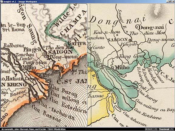
Picture below: A comparison of two historical maps showing Southeast Asia, both published in 1844. The map on the left is “Hinter Indien,” drawn by German Cartographer Carl Radefeld. The map on the right is “Burmah, Siam, and Cochin China,” drawn by British Cartographer John Arrowsmith. Both maps look similar when viewed in their entirety (see “Digital Dataset Critiques” in Editorial). When zoomed in close (below), we can see abundant and interesting differences in physical features, toponyms, and political delineations. Digital imaging allows this kind of examination on the Web.
Notes:
- Thongchai Winichakul, Siam Mapped. A History of the Geo-Body of a Nation (Honolulu: University of Hawaii Press, 1997), p. 154. ↩
- David Rumsey, “Tales from the Vault: Historical Maps Online,” Common-Place 3(4), July 2003, http://www.common-place.org/vol-03/no-04/tales/. ↩
- The author acknowledges with gratitude the assistance of David Rumsey, Anna Miller, Jeanette Zerneke, Samuel Otter, and John Radke ↩