

Plans to make the Mekong navigable to bigger boats by blasting rapids and shoals threaten to end a way of life for thousands of villagers.
The sky rumbles in the distance and cold wind blasts 59-year-old Malee Luangvises as he looks up at the thunderclouds above his village by the Mekong River in Chiang Rai’s Chiang Khong District. The coming of rain in the summer should make a fisherman such as Malee happy because it brings the fish. However, Malee no longer eagerly prepares his fine net to fish on the riverbank as he used to do. “There are fewer and fewer fish,” he says pensively.
Malee says that since border tensions with Laos eased in 1987, dynamite from China has been used intensively to catch fish in this area. This practice has depleted fish stock so extensively that he estimates the fish will disappear altogether within five years if it continues. “They [the dynamite fishermen] remove enough fish to fill a pickup truck with five explosions,” Malee says.
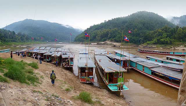
However, Malee might not have to wait five years until the fish are gone – along with the fishing-based lifestyle he leads along with neighbours in about 10 Thai and Lao villages in the section of the river between Chiang Saen and Chiang Khong. Much larger explosions will soon take place to partially blow up the Kon Pi Luang (Kaeng Kai Rapids) behind his village of Bang Kaeng Kai. This is part of the waterway-improvement project under the regional Commercial Navigation Agreement signed on 20 April 2000 by China, Burma, Laos and Thailand.
Since the first joint investigation into the possibilities of waterway transportation on the Upper Mekong River was conducted in 1993, the four countries have developed the concept, culminating in them signing the agreement. The aim is to enable vessels of any of the contracting countries to sail freely along the 886 kilometre route between Port of Simao in China and Luang Prabang in Laos under the six common navigation regulations.
However, the 331 kilometres of waterway from China-Burma Boundary Marker 243 to Ban Khok Luang on the Thai-Laos border contains more than 100 shoals, rapids and reefs of which 11 major rapids and 10 scattered reefs seriously threaten the safe navigation of vessels. These include Kon Pi Luang.
“They are dangerous areas which need specific navigation knowledge. Most vessels are from China [60 to 150 tonnage] and can navigate [the river] only in the wet season,” explains Preecha Petchwong, secretary of the Joint Committee on Coordination of Commercial Navigation on the Lancang-Mekong River. About 50 accidents have been reported including 10 severe incidents in which vessels were sunk and cargoes lost. Nine were caused by the vessels striking reefs. Seventy per cent of these happened at the shoals or rapids to be regulated under this project.
In order to minimise accidents and prolong the navigable period, the plan is to remove the rapids, shoals and scattered reefs. This will enable vessels of at least 100 tonnes to navigate safely for at least 95 per cent of the year. “When the project is finished, we won’t need the specific navigation knowledge that only the Chinese skippers have,” says Preecha, adding that it would mean boats could travel up the river faster and make it more viable as a trade route. “It will be more possible to transport agricultural goods such as frozen chicken upstream. People eat chicken the whole year, not just in the rainy season,” he said. “Regulations relating to trade will meet an international standard.”
Those behind the project predict that cargo volume will reach 1.5 million tonnes and the number of passengers travelling via the river will reach 400,000 by 2010. According to Preecha, trade between China and Thailand was 400,000 tonnes last year. Thailand mainly trades dried longan, tires and groceries while China trades apples and other winter fruits. “If you haven’t planned a way to compete in the market [created by the improving of the waterway], do it immediately,” says Preecha. “I told Laos this because Laos said they wouldn’t get anything from this agreement. If they don’t start doing something but complain they will get nothing. As a friend all I can say is, ‘I can’t help’. Developing the country is up to them.”
He said the project’s Environmental Impact Assessment (EIA) clearly indicates that the benefits of the rapid development of the waterway will be the stimulation of tourism, trade and technical and economic co-operation between the four countries. However, the project excludes the other two riparian countries that use the river: Cambodia and Vietnam.
Meanwhile, there is the issue of the Mekong River Committee (MRC). This is a regional body whose job is to provide the basis for co-operation in all fields of sustainable development, utilisation, management and conservation of the water and related resources of the Mekong River Basin including navigation. Of its member countries, Vietnam and Cambodia have not had any roles in the waterway-improvement project except providing assistance with the EIA.
Further, Thailand and Laos are members of MRC but China and Burma are not.”The MRC doesn’t have a clear vision on inter-issues like this,” says Premruedee Daoruang, director of Towards Ecological Recovery and Regional Alliance.”They should have had an active role before the project was developed. Otherwise, how can they claim to have a co-operative role for the mutual benefit among the downstream countries.” Preecha insists that Vietnam and Cambodia will still gain indirect benefits as a project called “W1” will complete the sub-regional transport links as part of the Greater Mekong Subregion Initiative development programme.
As well as the omission of Cambodia and Vietnam, at the community level the project has also failed to take into consideration the likely destruction of the way of life of locals like Malee. For Malee, the river is his main source of food and income the whole year round. During the rainy season when the water level rises, from May to October, Malee used to wander along the riverbanks in the early morning pitching 20 to 50 fishhooks of various sizes baited with earthworms on the banks. He could catch two to three kilograms of pla kod lueang (yellow mystus), pla kang (kod kang, Hemibagrus wickioides) and so on that could be sold for Bt100 to Bt150 kilo.
He also applies bedrao (trotlines) baited with small fish to lure pla mong (basa catfish, Pangasiusbocourti), pla khae (Bagarius yarrelli), and pla khor (Schistura sp). During the daytime, Malee would move to the Houai Tu tributary near the village to catch pla bok (Sroikhao, Henicorhynchus siamensis) and other fish the size of his palm. When the water level drops in the dry season, from November to late April, the rapids become Malee’s sole source of food during the daytime.
“Most of the fish such as pla khae, pla kaeng [Cirrhinus chiensis] and pla kod swim in the strong current during the day. Other fish like pla mong, pla buek [Mekong Giant Catfish, Pangasianodon gigas], pla sapak [Barbodes gonionotus] feed on the blue-green algae growing on the rocks,” says Malee. This circle of life secures Malee and his family can survive even though he earns little in cash.
Based on the local knowledge of fishermen surveyed by the Southeast Asia Rivers Network (SEARIN), rapids comprise sub ecosystems ranging from don (shoals), pha (cliff-like rapids), had (beaches), kok (whirlpools) and long (pools left after the water level drops). A variety of plants and fish rely on these systems in different seasons as their habitat, spawning grounds, feeding grounds and so on.
“Big fish lay eggs in the channel in the middle of the shoals,” Malee explains. “The water is [up to] just around the waist. We often stretch mong [driftnets] over the channel’s mouth to catch the fish. I have seen pla pia [Kadam, Morulius chrysophykadian] and pla chado [Channa micropeltes] breed their juveniles in the area.”
Chainarong Sretthachau, director of SEARIN, says the EIA was poor in quality in both social and environmental aspects. “It fails to address the significance of shoals and rapids as part of the riverine ecosystem that sustains plants and animals,” explains Chainarong. “There’s very rough information on likely impacts on fishery. Blasting rapids without thorough studies threatens the ecosystem and fishing gear will be incompatible once fish behaviour is disturbed.”
Chainarong says the project might change the river course and flow velocity, which will affect the way of life of other villagers downstream who also rely on the river such as farmers on the riverbanks, passenger-boat drivers and others. “A self-reliant economy is the core of the community’s economy,” says Chainarong. “If we destroy the economy from the grass roots, the macro-economy will be worth nothing because people can’t survive. This mainstream development should be diverted or slowed down. And the decision-making process should pay respect to people who will be affected by the development.”
For Malee, this consultation has yet to happen and it is never likely to. Above his village the sky still thunders, reminding him of the news of the blowing up of the rapids brought to him recently by his Laos friends. “The rocks are so enormous in size. How can they remove them?” asks Malee. “If they really do that, I can’t stop them because I am just a small man. The shoals and rapids will be gone. The fish will have no place to live any more. “
Malee then looks pensively to the mountain on the opposite site of the road and contemplates his predicament. The hot weather during dry season is so harsh that it leaves nothing but yellow dried leaves on the trees. “I’ll have to move to the mountain if I can’t fish in the river,” says Malee with an ironic grin. “I just hope there will be some bamboo shoots for my family.”
Piyaporn Wongruang
This article appeared in Bangkok’s The Nation, 9 July 2002.
Kyoto Review of Southeast Asia. Issue 2 (October 2002). Disaster and Rehabilitation