
The Burma-Bangladesh borderland? 1 At first sight, this seems to be one of the world’s most marginal places. In the current global power scheme, neither Burma (Myanmar) nor Bangladesh is of much concern. The margins of these societies, and what happens there, have little world media appeal. In the national media in Burma and Bangladesh, the borderland that joins them is rarely put in the spotlight, even in writings about border issues. For example, when we read about the border of Burma, usually it is the long border joining Burma and Thailand; when we read about the border of Bangladesh, usually it is the long border joining Bangladesh and India.
So why focus on a region that seems to be of little concern to anyone except those who live there? Well, there are many reasons. First, what popular or politicians’ perceptions marginalize need not be so marginal in reality. Second, looking at the world from border regions provides us with an outlook that challenges “lazy assumptions” that state and society, state and nation, or state and governance are synonymous or territorially coterminous (Anderson and Dowd 1999:602-603). Third, the discourse on transnationalism suggests a different way of conceptualizing social space in which not just global diasporas and financial markets but also communities that “live across borders, survive despite them, routinely cross them and constantly network around them” become indispensable objects of study (Rabinowitz 1998:142).
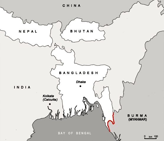
A closer look at the seemingly remote Burma-Bangladesh borderland (see Map 1) reveals a hive of activities with unexpected transnational importance. In this note, which builds on a broader study, I explore some of the linkages between border communities and transnational flows (Van Schendel 2005).
A Buoy in the River
The Naf River struggles through the mountains of Burma and Bangladesh before it spreads out into a wide expanse of water and flows into the Bay of Bengal. Plate 1 shows the view from the sea. In the background are the mountains of Arakan (Burma) and in the forefront a buoy whose significance is not apparent to the casual observer.
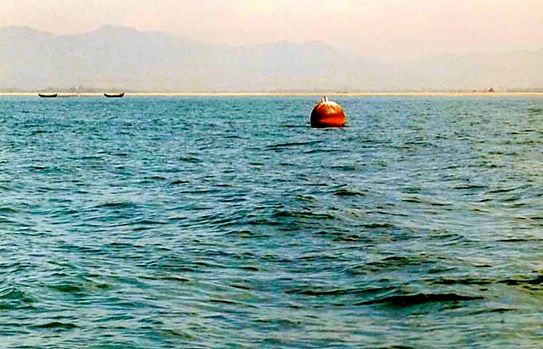
Photograph: Willem van Schendel, 2001.
This buoy demarcates the boundary between two worlds. It is the southernmost marker of the border between the states of Bangladesh (to the left) and Burma. It shows the exact territorial location of the jurisdictions of two neighbouring states. For many politicians it also marks the boundary between two global political regions. Here the world of ASEAN meets the world of SAARC. ASEAN stands for “Association of Southeast Asian Nations,” a collaboration of states who present themselves as “ten nations, one community.” Burma joined this group in 1997. Bangladesh, on the other hand, is the easternmost member of another club of seven states, SAARC (South Asian Association for Regional Cooperation). The buoy thus separates two world regions, South Asia and Southeast Asia. Both of these are relatively new: they were constructed by politicians in the post-World War II period. Academics have followed suit: creating “area studies,” they have produced knowledge that has tended to follow the political contours and assumed that Burma is best understood as part of a group of societies known as Southeast Asia and Bangladesh as part of South Asia (Van Schendel 2002). As a result, for 60 years most students of Burma and of Bangladesh have been standing with their backs to each other.
Before that time things were very different. The territories of both Burma and Bangladesh were administered by one state, British India. As an international border, the line separating Burma and Bangladesh is relatively young. It came into being as a humble boundary line between districts of British India. When this huge colony was split into British Burma and British India in 1937, the border took on a semi-international status for the first time. It became fully international when the British relinquished power in India/Pakistan (1947) and Burma (1948). Independent Burma now shared a border with the two independent states that resulted from the Partition of British India, India, and Pakistan. This note deals with the Burma-Pakistan segment only. In 1971 a revolt in Pakistan led to a war of secession in which a new state, Bangladesh, emerged. The border between Burma and Pakistan then became the border between Burma and Bangladesh (Map 1).
Remarkably, after all these permutations, there is still no agreement on where the border actually is. Or indeed how long it is. The Bangladesh government and the CIA think that its length is 193 km but according to Burmese sources it is 272 km (“Resist” 1999; CIA 2000; Basic Facts 1996). It is a border that remains almost completely undemarcated despite land boundary agreements in 1966, 1980, and 1998 (Haque 1980:218; “Border Tense” 2001). Not surprisingly, territorial uncertainty has given rise to continual frictions and border incidents. Only in the mouth of the river Naf have buoys been placed to separate Burmese waters from Bangladeshi ones and to guide ships coming in from the Bay of Bengal. Upstream the border is less clear, as the authorities found out right after it was created. When some previously uninhabited islands in the Naf river were occupied by people from Burma shortly after Partition, the Pakistan authorities went on a wild goose chase in offices in Dhaka, Chittagong, and Cox’s Bazar for documents and maps which could establish their right over these islands. Eventually they had to concede that “the boundary between Chittagong and Arakan districts along with the Naf river do not seem to have been formally demarcated after the separation of Burma [in 1937]. The latest Record in this point is the Revenue Settlement map, prepared in 1929” (Bangladesh 1950).
In the early 1990s the Tumburu watercourse, linked to the Naf River, moved north, causing great friction between Burmese border guards (Nasaka or Na Sa Ka), who continued to use it, and their counterparts in Bangladesh, who claimed that it was now in Bangladesh. In April 2000, Burma finally conceded that the watercourse had moved out of reach (“Nasaka” 2000).
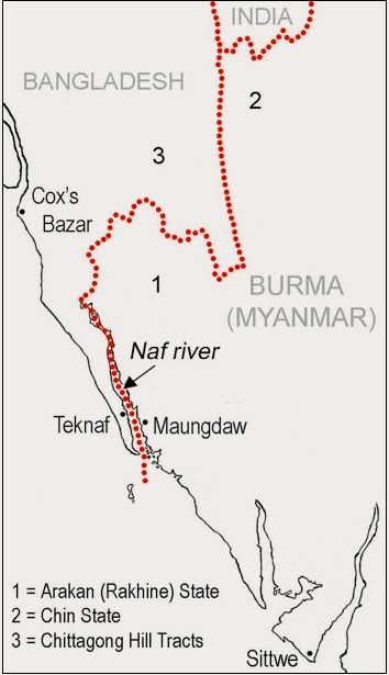
Further east the border runs over land and here the territorial uncertainty can have lethal consequences (Map 2). Burma’s armed forces have been caught up in endless skirmishes with various rebel groups fighting for independence. In the early 1990s the authorities began laying anti-personnel mines in the borderland.
The mines do not discriminate when it comes to taking lives. Among the victims were BDR Jawans [Bangladesh border guards], Myanmar’s Nasaka security forces personnel, Myanmar regular army troopers, Rohingya infiltrators and Bangladeshi woodcutters. A total of 35 Bangladeshis have been killed and 22 wild elephants perished due to landmine blasts at the border areas during the six-year period (Islam 1999).
Burmese border guards and separatists such as the Rohingya Solidarity Organisation (RSO) often clashed over control of the border. On one occasion, RSO rebels killed 11 guards who were laying anti-personnel mines along the border with Bangladesh. Another encounter left one border guard and two RSO fighters dead and 32 others, from both sides, wounded (“Three” 1998; “Tension” 2000).
Being a Borderlander
For two generations now, inhabitants of this region have been adapting to life in an international border landscape. Their adaptations have been manifold: learning one or both of the national languages (although certainly not everybody speaks Burmese or Bengali today), using two currencies that cannot officially be traded, making a living off unauthorized cross-border trade, keeping in touch with relatives on the other side, seeking refuge across the border and, whenever necessary, appeasing the armed men who are stationed there. Becoming a borderlander has turned into a never-ending project. It is shaped by local forces as much as by national and transnational ones. The following examples show different combinations of these.
Ignoring the Border
An undemarcated border invites border clashes if the states concerned attempt to enforce territorial control. Much of the Burma-Bangladesh border remains unpatrolled, however, and the movement of people across it is hardly monitored. In the difficult hilly terrain in the east, there are few border outposts and the state is largely absent: the director-general of the Bangladesh border guards (the Bangladesh Rifles, or BDR) complained that 100 km of this border remain not only undemarcated but also unprotected because there are no border outposts at all (“DG” 2000). A border that is neither visible nor manned is not a social reality. In the absence of effective state checks on spatial mobility, local people belonging to many border-straddling ethnic groups here (Mru, Marma, Sak, etc.) continue to move back and forth, cultivating land in two countries and maintaining strong cross-border webs of kinship and sociability. The absence of state forces also exposes them to violence from across the border. Looting borderlanders’ property is common, and when victims try to defend themselves, casualties easily occur. For example, the inhabitants of a Mru village on the Bangladesh side put up strong resistance when thirty robbers from the Burmese side attacked them. The villagers killed three attackers and wounded thirteen, while only two villagers were wounded. Kidnapping for ransom is another form of cross-border crime, used by some rebel groups to finance their struggle, e.g. the Arakan Democratic Party which abducted Marma men from Bangladesh to Burma (“Myanmar” 1998; “Two” 1999).
Riding the Trade Flows
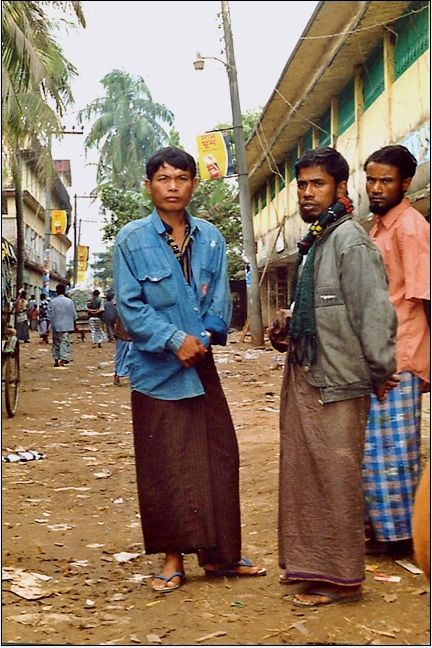
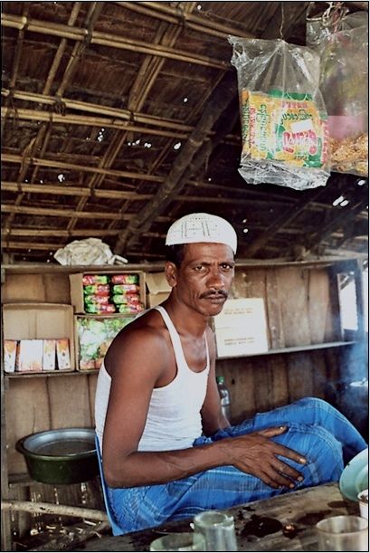
At the very southern tip of Bangladesh, a quiet spit of land extends towards Burma. The road ends at the small river port of Teknaf. Across the wide expanse of the Naf River, the sunlight reflects off a pagoda on the Burmese side. Rusty old coasters and wooden country boats are waiting for the tide to come in. Boats can enter the short Teknaf tributary only at high tide. The boats, sporting Burmese and Bangladeshi flags, may be old and small and Teknaf may look like a sleepy place, but appearances deceive (Plate 2).
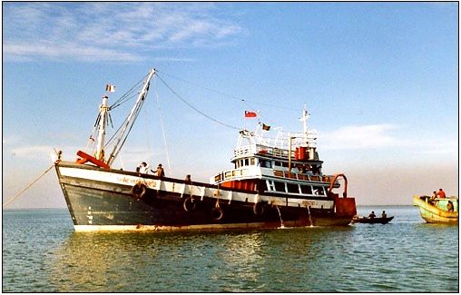
Photograph: Willem van Schendel, 2001
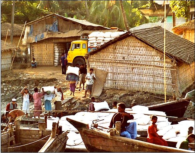
Teknaf and its counterpart Maungdaw across the river carry on a lively, mostly illegal trade in goods from all over the world. Local traders can get a daylight permit to visit the other side and many others cross without state authorization (Plate 3). Legal trade goods from Burma are often registered as coming from Singapore. Including these goods, the president of the Bangladesh-Myanmar Business Promotion Council estimated that official Bangladesh imports from Burma come to some US$170 million (“Trade” 1999; “Yangon’s Strict” 2003). Official trade covers only a few dozen types of goods, however, and it is completely dwarfed by illegal trade: possibly over 90 percent of the goods entering Teknaf are smuggled (Smith 1986; Ghafur, Islam and Faiz 1990-91). A bewildering array of goods cross the border here and the complexity of trade networks passing through the Burma-Bangladesh border is impressive (Plate 4). From the Burmese side come goods from Thailand—nylon ropes, hosepipes, cosmetics, and fish—and from China—electrical goods and crockery—that have been transported by road across Burma. Burma itself provides clothes, spices, shrimps, rice, cigarettes, whisky, beer, salt, and antiques. Arms and ammunition from various parts of the world also enter Bangladesh here.
talking to Bangladeshi partners.
Photograph: Willem van Schendel, 2001
The smuggling of small arms reveals a link between unauthorized trading and the many insurgencies in the region. Rebel groups in Arakan and Chin State (Burma), the Chittagong Hill Tracts (Bangladesh), and Northeast India depend on supplies passing through the borderland. Some arms follow the sea route to a Bangladesh port and are then smuggled to India, others come over land via Burma. Smuggled arms vary from handguns and “chocolate bombs” made locally in, for example, Moheshkhali (an island off the coast of Chittagong), to assault rifles, submachine guns, anti-tank devices, and rocket launchers produced in the United States, Russia, Israel, China, or Belgium (Van Schendel 2005:165-168, 185-186). According to the Small Arms Survey 2001, “Bangladesh is a major transit point for arms in the region. Small arms come across to Bangladesh from Afghanistan and Pakistan on the one side, and from Thailand, Singapore, Myanmar, and Cambodia on the other. From there, the weapons usually go north to rebels in India’s north-east or south to the LTTE [Liberation Tigers of Tamil Eelam]” (Small Arms Survey 2001:182).
Cox’s Bazar, a seaside town in Bangladesh (see Map 2), profits especially from the small arms trade. Here customers from abroad, but also from Bangladesh itself, come to shop for the latest merchandise arriving largely by sea. Cox’s Bazar is linked with a network of local arms bazaars in the borderland, for example the “trijunction point” where India, Burma, and Bangladesh meet. “You can get anything here,” says Laldina, a member of the Chin Army that is fighting the Burmese state, “from the smallest handgun to a rocket launcher, from the Russian Kalashnikov to a Chinese version of the AK-47, from the American M-16 to the German HK33” (“Mizoram” 2000; “Bullet Smuggling” 2001). Increasingly, illegal small arms are also available to local entrepreneurs and politicians, turning both cross-border trade and borderland politics into bloodier affairs than before.
In the 1980s, the borderland developed into an important channel for the trade in Burmese heroin. As a result of increasing military pressure on heroin manufacture in the Shan States (eastern Burma), heroin refineries were established in Chin State close to the Bangladesh and Indian borders. Large quantities of Burmese heroin began to be routed through Northeast India and Bangladesh for transshipment to European and North American markets. At the same time, local consumer markets developed along these trade routes. Soon the Teknaf border became a region with a relatively high concentration of heroin users. Today the region is well integrated into the worldwide circulation of heroin. Heroin has established itself as a routine trade item and some opium poppy is being grown on the Bangladesh side of the border as well (“Crackdown” 2002; “Poppy” 2005).
Photograph: Willem van Schendel, 2001
Trade from Burma to Bangladesh includes many commodities, but boats from Teknaf take an equally varied range of goods to Maungdaw. Some of these goods originate in Bangladesh; others come from India or further afield. Among Bangladeshi and Indian goods in Burma are fertilizers, scrap metal, pulses, biscuits, kerosene and diesel, contraceptives, and even rice.
The local economy is dependent on this trade and many locals benefit from it. Trade operators are often not locals, however; they are bigger traders living in cities and some have crucial links with the states that formally prohibit this trade. In fact, high-level bureaucrats and politicians have emerged as major organizers, financiers, and facilitators of illegal trade in their own right. Sometimes such practices are integrated completely into state institutions. This was the case with the Burmese Military Intelligence Battalion MI 18, stationed at the border town of Maungdaw. This unit owned a six-crew sea-going ship, the Saw Mratt Radana, used for regular smuggling to Bangladesh, until the Bangladesh authorities captured it (“Bangladesh Returns” 2003).
The illegal nature of almost all trade between Burma and Bangladesh makes it highly profitable but also pretty dangerous. Cross-border traders have to rely on trust rather than on law enforcement and the Naf River is known as a place where trust can break down easily and where trade partners can turn into robbers. Thus men originating from Maungdaw in Burma (but now settled on the Bangladesh side) have been reported as robbing Burmese smugglers and then killing them by hand or drowning them in the border river (“Smugglers” 2000).
Minorities and Diasporas
The creation of an international border in 1947 produced new ideas of national citizenship. The population of what was now the borderland was the result of centuries long intermingling of different linguistic, religious, and social groups. Nation building in Burma and Pakistan/Bangladesh led to new power differences in the border region as some groups were now singled out as national minorities. Sometimes minorization was mainly economic (Van Schendel 2001). This was the case with the Rakhain—Arakanese-speaking Buddhists—on the Pakistan/Bangladeshi side. Soon after the creation of the border, they found that their main livelihood, weaving, was being threatened and that they had no power to move the state to take their interests into account. Partition cut them off from both their source of raw material, silk, and their market. They produced various silk textiles for the Burmese market which now, because of new import and export restrictions, became so difficult to reach that most producers had to abandon their trade. Many switched over to the production of cigars and cheroots, for which local tobacco could be used. This seemed to offer a solution until the Pakistan government decided to slap a double duty “once on raw tobacco and then on cigars and cheroots…. Due to this latter tax, the manufacture of cigars and cheroots by these people ha[s] stopped as they cannot find a market. The market is flooded with foreign cigars and cheroots which are sold at cheaper rates than the local products.” As a result, “being unable to cope with the changed conditions [the Rakhain] have already begun in hundreds to migrate to Burma against their will just in an attempt to save their lives” (U Chin 1953). Since then, many more Rakhain from Bangladesh have had to move to Burma, leaving a dwindling population in Bangladesh (Plate 5).
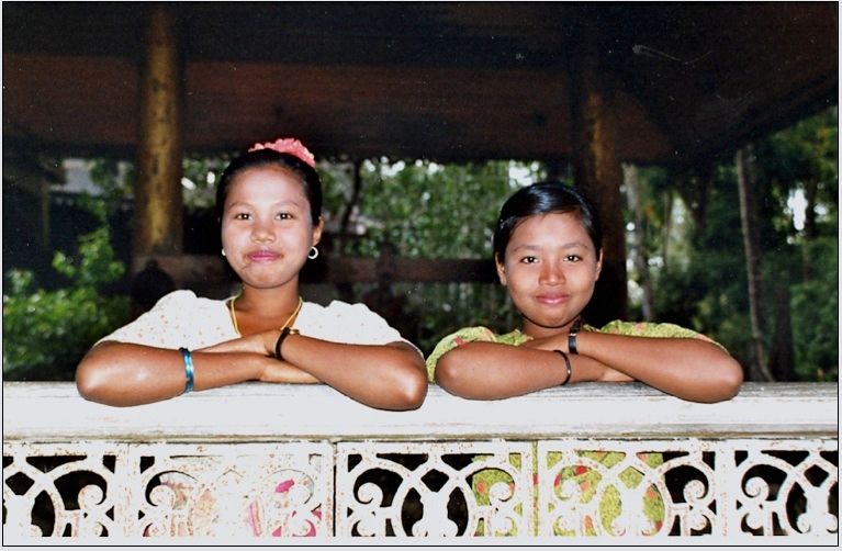
Photograph: Willem van Schendel, 2001
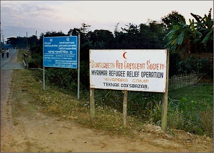
An example of a more violent political form of borderland minorization is provided by the fate of the Rohingya—inhabitants of the Burmese side of the borderland who speak Chittagonian-Bengali and who profess Islam. Right from the start the independent Burmese state considered the Rohingya to be of doubtful loyalty, partly because some of them had sought to create an independent state in northern Arakan or to incorporate it into Pakistan (Human Rights Watch 1996:10). Rohingya were not recognized as Burmese citizens and in 1948 Burmese armed forces carried out operations against them. Hundreds of villages were “put to the torch and thousands were mercilessly killed, triggering a massive refugee exodus to the then Pakistan” (Yunus 1995:3). This set the stage for future attempts by the Burmese authorities to terrorize and expel the Rohingya, leading to repeated waves of refugees into Pakistan and later Bangladesh (Smith 1994a; 1994b; Ahmed 2004). At first the authorities here welcomed them as mohajirs (Islamic refugees) and, according to press reports, planned to build them kolchoze-like model villages (“Chottograme” 1949). These never materialized and soon Rohingya were treated as aliens. In the early 1990s, over 250,000 Rohingya refugees were living in UN supervised borderland camps in Bangladesh. Some later returned to Burma, others melted into Bangladesh society, and some 20,000 are still living in camps near Teknaf (Plates 6 and 7). At least 100,000 others lived outside the camps and the Bangladesh authorities considered them to be illegal, uncleared, or residual refugees, or merely “arrivals.” In 1999, at least 1,700 of them were in Bangladeshi jails on the charge of illegal border crossing (UNHCR 1997:254; “Twenty-five” 1999).
Photograph: Willem van Schendel, 2001
Destitute, stateless Rohingya refugees did not stay put in the border region. Large numbers are known to have migrated to the big cities of Bangladesh, to Malaysia, to Pakistan, and from there to the Gulf countries, where over 200,000 were thought to reside in the 1990s (Lintner 1993; Human Rights Watch 2000). Some Rohingya received support from militant Islamist organizations and joined the fighting in Afghanistan where they were given the most dangerous tasks in the battlefield, clearing mines and portering (Lintner 2002). The Burmese state’s distrust of a border community thus led to a rapid international diaspora which has now spawned its own Rohingya Internet communities and news sources. 2
on the Bangladesh bank of the Naf River.
Photograph: Willem van Schendel, 2001
Geopolitics at a Forgotten Border
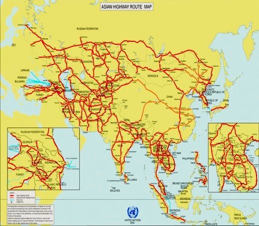
Source: http://www.unescap.org/ttdw/common/TIS/AH/maps/AHMapApr04.gif
In recent years the border has become the focus of two geopolitical games. The first is the “Asian Highway.” Initiated in 1959 by ECAFE (Economic Commission for Asia and the Far East) and now pursued by UNESCAP (United Nations Economic and Social Commission for Asia and the Pacific), the Asian Highway is still a project rather than a reality. Although UNESCAP’s maps show that the Bangladesh section of this highway will run through central Bangladesh and via Northeast India into northern Burma, the Bangladesh government wishes it to run through southern Bangladesh and via coastal Burma (Arakan) to Rangoon (Yangon) (Map 3). In this way traffic and goods can be exchanged between Bangladesh and Southeast Asia without the involvement of Bangladesh’s huge neighbour, India. In 2002 Burma and Bangladesh agreed to route the Asian Highway through Teknaf and Maungdaw, but more recently Burma opted for the route via northeast India. Both India and Burma have now signed the UN Intergovernmental Agreement on the Asian Highway Network (2004) but Bangladesh is holding back (Intergovernmental 2004). Instead, it has begun work on the “Bangladesh-Burma friendship highway” through Teknaf to help establish a road link between Dhaka and Bangkok (“Highway” 2004). Plans to develop Teknaf into a major sea port, build a bridge across the Naf to link it with Maungdaw, and thus facilitate a rapid expansion of cross-border trade and traffic, have been discussed in Bangladesh for many years, but Burmese disinterest has thwarted these plans repeatedly.
The second geopolitical game involving the Burma-Bangladesh border concerns natural gas. Since 2000 the Burmese government has allowed South Korean and Indian oil companies (Daewoo, South Korea Gas Corporation, ONGC Videsh, and the Gas Authority of India Ltd) to explore gas fields in the Bay of Bengal off the Burmese coast. These explorations, known as the “Shwe Project,” proved very successful—some four to six trillion cubic feet of recoverable gas have been located and an additional seven to twelve trillion are expected (Naing Htoo et al. 2004:1). India is keen to buy the gas. The most cost-efficient way is to pipe it through Bangladesh but political expediency may set other priorities. Thus when Bangladesh and Burma were working out plans to upgrade the Teknaf-Maungdaw road and water connection to take much more (legal, and hence taxable, but mainly illegal) trade, India sprang into action. Survey teams began exploring the possibility of constructing a cross-border road and a gas pipeline through the hitherto inaccessible mountains linking Mizoram (India) with Chin State (Burma) at a point just east of the trijunction point where India, Bangladesh, and Burma meet (see map 4).
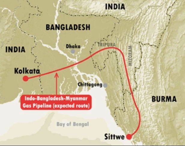
Source: http://www.irrawaddy.org/articlefiles/4325-ShweMap.gif
If Burma could be made to agree to such a scheme, India could count on a trouble-free supply of Burmese gas as well as a significant diversion of trade from Teknaf and so cut out Bangladesh (“Dhaka” 2002; “Indo-Burma” 2003). Tensions rose and 2005 found the three states discussing a joint pipeline from Burma crossing the Bangladesh border (Route 1 in Map 5) and possibly splitting into two branches, one entering India in Tripura and the other in West Bengal. The precise route and conditions of the pipeline are currently being discussed. Bangladesh demands that India—in return for Burmese gas via Bangladesh—allows Bangladesh transit facilities to import hydroelectricity from Nepal and Bhutan and to trade with these two countries (which do not share a border with Bangladesh). In addition, India should reduce the huge trade imbalance between itself and Bangladesh.
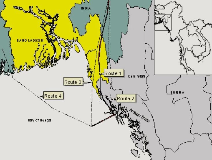
being discussed by the India, Bangladesh and Burma authorities in 2005.
Source: http://www.earthrights.org/burma/final-shwe-map.jpg
It is the global interest in fossil fuel resources that has suddenly increased international awareness of the Burma-Bangladesh borderland. The Shwe Gas Movement—comprising activists from Bangladesh, Burma, and India as well as organizations such as Earth Rights International and Oilwatch SEA (see Plate 8 and “Arakan Bodies” 2005; “Arakan Gas” 2005; Mukherjee 2005; Jockal 2005)—highlights the possible adverse effects: forced labour, dislocation of people, confiscation of land, human rights abuses, support for an illegitimate military regime, and environmental destruction in the borderland. 3
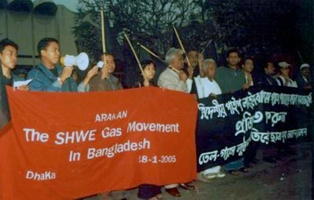
Dhaka, 18 January 2005.
Source: www.oilwatch.org.ec/english/galeria.htm
This campaign—as well as deliberations by officials in Delhi, Rangoon, and Dhaka—will determine whether the long-neglected Burma-Bangladesh borderland will see an upsurge in infrastructural development, a concomitant expansion of the border economy, and a shift in the relative size of authorized and unauthorized flows of goods and people across the border—or whether it will continue much as it has in recent years.
The current campaign may make this border region more visible to larger groups of people in Burma and Bangladesh, in Southeast and South Asia, and worldwide. It may also alert scholars of (Southeast) Asia to the importance of studying borderlands. The obscurity of borderlands is merely an optical illusion and their current marginalization in social science is a symptom of the state-centricity of most social science education (Donnan and Wilson 1999). Like other borderlands, the region joining Burma and Bangladesh is an important site for the study of how local, national, and international forces simultaneously shape human life and how border communities and transnational flows are linked (Van Schendel 2006). The study of borderlands may suggest new ways of conceptualizing social space in a century in which state-centric concepts are widely felt to be insufficient.
Willem van Schendel
Willem van Schendel teaches at the University of Amsterdam and the International Institute of Social History.
He can be reached at h.w.vanschendel@uva.nl
(The urls below were working at the time of original publication in March 2006)
References
Ahmed, Imtiaz. 2004. “Refugees and Civil Society: Rohingya Refugees in Bangladesh.” In State, Society and Displaced People in South Asia, ed. Imtiaz Ahmed, Abhijit Dasgupta and Kathinka Sinha-Kerkhoff, pp. 281-307. Dhaka: University Press Limited.
Anderson, James, and Liam O’Dowd. 1999. “Borders, Border Regions and Territoriality: Contradictory Meanings, Changing Significance.” Regional Studies 33, no, 7: 593-604.
“Arakan Bodies Opposed the Tri-nations MoU on Arakan Gas.” 2005. Kaladan News, 14 January.
“Arakan Gas Campaigners Hold Press Conference in Dhaka.” 2005. Narinjara News, 14 January.
Bangladesh. 1950. National Archives of Bangladesh (Dhaka), Government of East Bengal, Home (Political) Department, Branch Political, B. Proceedings, 20M-60/50 (3-53).
“Bangladesh, Myanmar Agree to Remove Trade Barriers.” 1999. The Daily Star, 19 July.
“Bangladesh Returns a Burmese Military Intelligence-owned Smuggling Vessel at a Flag Meeting.” 2003. Narinjara News, 26 February.
Basic Facts on the Union of Myanmar. 1996. Yangon: Public Relations and Information Division, Ministry of Foreign Affairs, Government of the Union of Myanmar.
“Border Tense as Myanmar Continues to Mass Troops: Nasaka Refuses to Sign Joint Statement.” 2001. The Daily Star, 22 January.
“Bullet Smuggling Rising on Bangladesh-Burma Border.” 2001. Mizzima News, 12 June.
“‘Chottograme Arakani mohajer,’ Panuapathare dui hazar loker bostir byobostha.” 1949. Azad, 14 April.
CIA. 2000. The World Factbook 2000. Washington, DC: Central Intelligence Agency, www.cia.gov/cia/publications/factbook/.
Crackdown on Poppy Farmers in Bandarban.” 2002. The Daily Star, 12 May.
“Declaration of the Rohingya National Convention.” 2004. Asian Tribune, 20 May.
“DG of BDR Concerned at Unprotected Borders of CHT, Satkhira.” 2000. The Daily Star, 4 July.
“Dhaka, Yangon Agree on Road Link: Two Taskforces Formed for Feasibility Study.” 2002. The Daily Star, 18 December.
Donnan, Hastings, and Thomas M. Wilson. 1999. Borders: Frontiers of Identity, Nation and State. Oxford and New York: Berg.
“Flag Meet Held: Dhaka, Yangon Agree to Begin Joint Survey.” 2001. The New Nation, 21 January.
Ghafur, Abdul, Muinul Islam, and Naushad Faiz. 1990-91. Illegal International Trade in Bangladesh: Impact on the Domestic Economy. Dhaka: Bangladesh Institute of Development Studies, Phase I 1990; Phase II 1991.
Haque, Azizul. 1980. “Bangladesh 1979: Cry for a Sovereign Parliament.” Asian Survey 20, no. 2: 217-230.
“Highway for Closer Cooperation.” 2004. Mizzima News, 2 May.
Human Rights Watch. 1996. “Burma: The Rohingya Muslims—Ending a Cycle of Exodus?” Human Rights Watch/Asia 8, no. 9.
——. 2000. Malaysia/Burma: Living in Limbo—Burmese Rohingyas in Malaysia. New York: Human Rights Watch.
“Indo-Burma Joint Survey in Western Burma.” 2003. Narinjara News, 16 January.
Intergovernmental Agreement on the Asian Highway Network. 2004. Shanghai: UNESCAP.
Islam, Mohammad Nurul. 1999. “Where Landmines Take a Heavy Toll.” The Independent, 28 May.
Jockal. 2005. “Burma’s Shwe Gas Project: Another Nightmare?” Mizzima News, 30 April.
Lintner, Bertil. 1993. “Distant Exile: Rohingyas Seek New Life in Middle East.” Far Eastern Economic Review 156, no. 4, 28 January.
——. 2002. “Championing Islamist Extremism.” South Asia Intelligence Review 1, no. 9, 16 September.
“Mizoram Border Safe Haven for Gun-runners, Insurgents.” 2000. The Northeast Daily, 29 March.
Mukherjee, Supratim. 2005. “Myanmar: Cheers, Jeers over Giant Gas Find. Asian Times, 14 February.
“Myanmar Gunmen Killed in Bangladesh Border Battle.” 1998. ShweInc News, 24 October.
Naing Htoo et al. 2004. Another Yadana: The Shwe Natural Gas Pipeline Project (Burma-Bangladesh-India). Earth Rights International. www.earthrights.org.
“Nasaka Won’t Use Tumburu Canal.” 2000. The New Nation, 29 April.
“Poppy Cultivated on 100 Acres in Bandarban Destroyed.” 2005. The Daily Star, 9 March.
Rabinowitz, Dan. 1998. “National Identity on the Frontier: Palestinians in the Israeli Education System.” In Border Identities: Nation and State at International Frontiers, ed. Thomas M. Wilson and Hastings Donnan, pp. 142-161. Cambridge: Cambridge University Press.
“Resist Smuggling Nasim Tells BDR Personnel.” 1999. The Daily Star, 22 March.
Small Arms Survey 2001: Profiling the Problem. 2001. Geneva/Oxford: Graduate Institute of International Studies / Oxford University Press.
Smith, Martin. 1986. “Sold Down the River: Burma’s Muslim Borderland.” Inside Asia (July-August): 5-7.
——. 1994a. Burma: Insurgency and the Politics of Ethnicity. London: Zed Press.
——. 1994b. Ethnic Groups in Burma: Development, Democracy and Human Rights. London: Anti-Slavery Society.
“Smugglers Robbed at Bangladesh-Burma Water.” 2000. Mizzima News Group, 13 July.
“Tension along Bangladesh-Myanmar Border. 2000. The Times of India, 18 November.
“Three Reported Dead as Guards Fight Rebels.” 1998. The Mekong Digest, 28 January.
“Trade with Myanmar: Jetty on Naf River Soon.” 1999. The New Nation, 4 August.
“Twenty-five Rohingyas Languishing in Chandpur Jail.” 1999. The New Nation, 27 October.
“Two Abducted Men Released in Bandarban.” 1999. The New Nation, 23 June.
U Chin. 1953. “Report on the Migration of Arakanese Buddhists to Burma.” National Archives of Bangladesh (Dhaka), Government of East Bengal, Home (Political) Department, Confidential Records B. Proceedings, CR 9M-14/53 (6-54).
UNHCR. 1997. The State of the World’s Refugees: A Humanitarian Agenda. Oxford: UNHCR/Oxford University Press.
Van Schendel, Willem. 2001. “Working Through Partition: Making a Living in the Bengal Borderlands.” International Review of Social History 46: 393-421.
——. 2002. “Geographies of Knowing, Geographies of Ignorance: Jumping Scale in Southeast Asia.” Environment and Planning D: Society and Space 20: 647-668.
——. 2005. The Bengal Borderland: Beyond State and Nation in South Asia. London: Anthem Press.
——. 2006. “Spaces of Engagement: How Borderlands, Illegal Flows and Territorial States Interlock.” In Illicit Flows and Criminal Things: States, Borders, and the Other Side of Globalization, ed. Willem van Schendel and Itty Abraham. Bloomington: University of Indiana Press (in press).
“Yangon’s Strict Control Creates Trade Imbalance.” 2003. The New Nation, 3 June.
Yunus, Mohammad. 1995. A Memorandum on the Genocide of the Rohingya Muslims of Arakan in Burma. Arakan: Rohingya Solidarity Organization.
Notes:
- I would like to thank Dr. Md. Mahbubar Rahman for his companionship during two visits to the Burma-Bangladesh border region. ↩
- See, for example, www.rohingyatimes.com/; www.rohingya.org/; www.geocities.com/rohingyalanguage/; www.helprohingya.tk/; and “Declaration” 2004. ↩
- See, for example, www.shwe.org/; www.earthrights.org/burma/shwepipeline.shtml; www.oilwatch-sea.org/new/shwe.html;www.geocities.com/arakangasmovement/arakangasmovement.htm; www.petitiononline.com/agm0401/petition.html. ↩